
Solution
Introduction to RIVAS
Faster project decisions and goals are achieved with
better information flow.
ICI’s RIVAS
Solution
is a software system + rapid implementation + professional support services, delivered by an experienced multidisciplinary team of experts.
Resulting integration, access, efficiency and transparency build trust with stakeholders and regulators to help a project move faster and reduce project risk in the process.
ICI has been developing, implementing and supporting custom systems for interactive data visualization and reporting since 2014. Along the way we recognized and addressed gaps in the market requiring the development of tools, processes and expertise to be more efficient at deploying, configuring and supporting these systems. This evolved into our RIVAS solution, our project information management system for better information flow. Built from necessity.
Collectively, we have participated in hundreds of projects across Renewable Energy, Mining, Oil and Gas, Transportation and Logistics, Utilities and Infrastructure, and Fisheries. Our multidisciplinary team of experts includes software developers, project managers, product managers as well as consulting scientists and professionals. We’re there as partners over the long-term to augment, supplement or support your project team as your requirements evolve with subsequent project phases.
ReportVIZ
Linked Report, Map Window, Layer Control and Table of Contents, provide interactive access and navigation of private and/or public project data, information, maps and reports with source verification.
Document Manager
Upload, search and access project documents via a simple-to-use interface. Properties are configured and enforced for each project. Content managed within SharePoint Online.
engagement Manager
Users track their engagement activities and communications, the stakeholders involved with associated feedback, and tasks that arise from carrying out stakeholder engagements.
supplier Registration
INSPECTION MODULE
In commercial development. Queries status from connected assets as a QA process to confirm information as verified/valid, or identify and flag issues with data or a reporting asset.
Management of Change
In commercial development. Requests to change infrastructure follow a submit, review, approve and implement workflow with reporting and dashboard tracking of requests and status.
SUBMISSION MANAGER
Workflow and interface for external contractor document upload including review, revision, approvals and notifications throughout the process to ensure consistency.
In-Form
LEARN ABOUT

LEARN ABOUT

LEARN ABOUT

LEARN ABOUT

LEARN ABOUT

ReportVIZ
Linked Report, Map Window, Layer Control and Table of Contents, provide interactive access and navigation of private and/or public project data, information, maps and reports with source verification.
Document Manager
Upload, search and access project documents via a simple-to-use interface. Properties are configured and enforced for each project. Content managed within SharePoint Online.
engagement Manager
Users track their engagement activities and communications, the stakeholders involved with associated feedback, and tasks that arise from carrying out stakeholder engagements.
supplier Registration
INSPECTION MODULE
In commercial development. Queries status from connected assets as a QA process to confirm information as verified/valid, or identify and flag issues with data or a reporting asset.
Management of Change
In commercial development. Requests to change infrastructure follow a submit, review, approve and implement workflow with reporting and dashboard tracking of requests and status.
SUBMISSION MANAGER
Workflow and interface for external contractor document upload including review, revision, approvals and notifications throughout the process to ensure consistency.
in-Form
In development. Provides a project proponent with a guided questionnaire and associated decision-tree populating RIVAS with defined and specific information, layers and project requirements.
ReportVIZ
Linked Report, Map Window, Layer Control and Table of Contents, provide interactive access and navigation of private and/or public project data, information, maps and reports with source verification.
Document Manager
Upload, search and access project documents via a simple-to-use interface. Properties are configured and enforced for each project. Content managed within SharePoint Online.
Engagement Manager
Users track their engagement activities and communications, the stakeholders involved with associated feedback, and tasks that arise from carrying out stakeholder engagements.
Supplier Registration
A publicly available, mobile-first website to register and categorize suppliers with an administrative component to search for and manage supplier information.
Inspection Module
In commercial development. Queries status from connected assets as a QA process to confirm information as verified/valid, or identify and flag issues with data or a reporting asset.
Management of Change
In commercial development. Requests to change infrastructure follow a submit, review, approve and implement workflow with reporting and dashboard tracking of requests and status.
Submissions Manager
Workflow and interface for external contractor document upload including review, revision, approvals and notifications throughout the process to ensure consistency.
In-Form
In development. Provides a project proponent with a guided questionnaire and associated decision-tree populating RIVAS with defined and specific information, layers and project requirements.
THE RIVAS SOLUTION INCLUDE
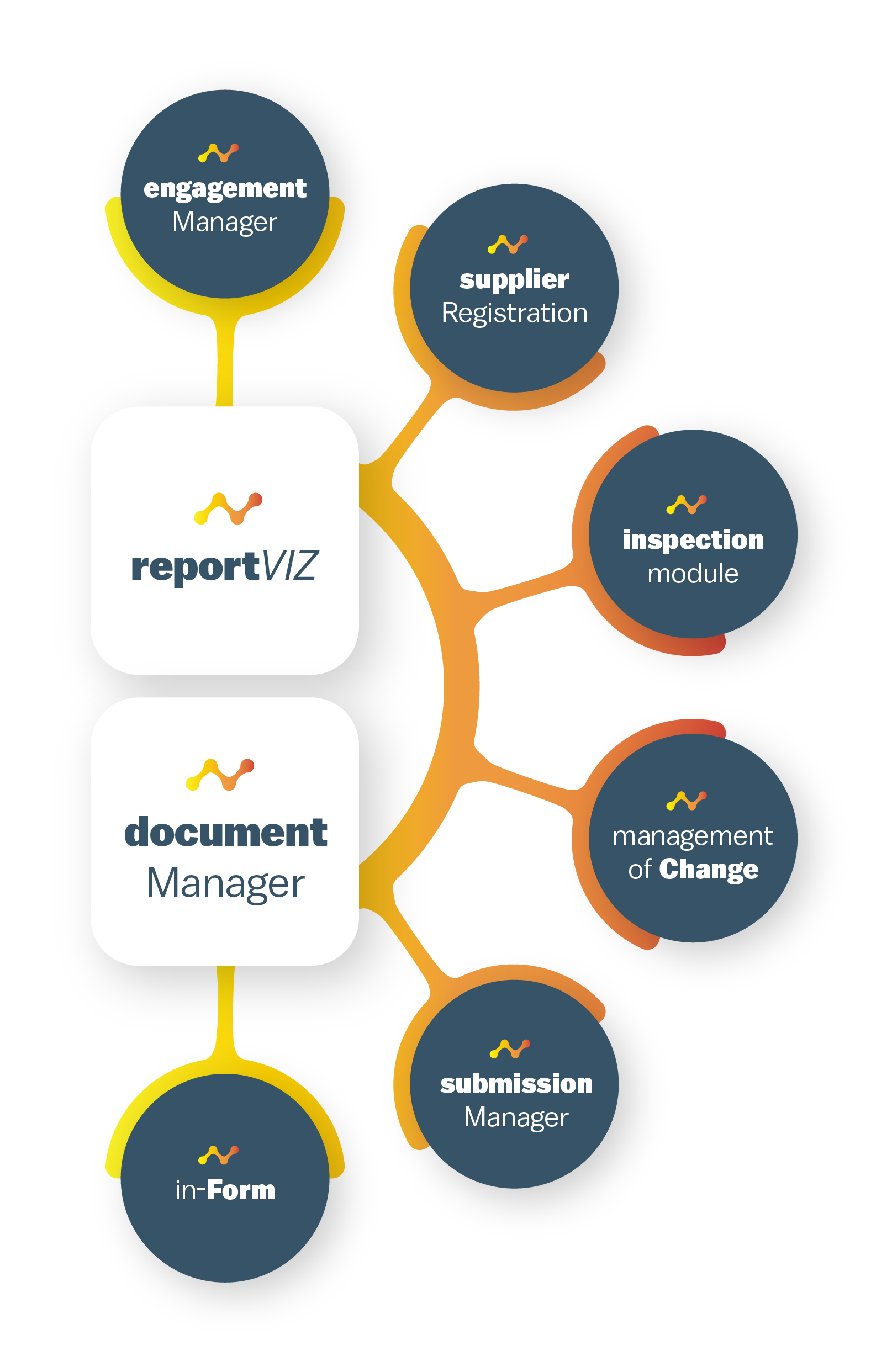
Software System
- Core modules – ReportViz + Document Manager
- Optional modules – Engagement Manager, Supplier Registration, Submissions Manager, Management of Change
Rapid Implementation
Professional Support Services


The RIVAS Plan solution is designed to be implemented early in the project lifecycle for a small project team at the planning phase. We know first-hand that you can’t be too early to get this set-up. Data, information and reports tend to grow significantly in breadth and volume at each successive stage. Better information flow early and throughout the project is vital.
RIVAS Plan is designed specifically for projects with smaller teams in the planning phase leading to Project Registration and EA submission. This solution has everything you need to plan, organize and structure your team and systems on a budget including supplier registration and/or engagement management when you need to add them. Migrating to the full Rivas Navigate solution is seamless, fast and easy when you need it.
INCLUDES
ReportViz
Document Manager
OPTIONAL
Engagement Manager
Supplier Registration
More Info
- 10 x User Logins via MS Teams
- Easy integration of geospatial and SharePoint data sources
- Support for base maps (ESRI, Azure, open-source)
- Spatial data filtering and query
- Collection of common document types
- Full reporting: draft/edit in MS Word, publish/view in ReportViz
- Local Knowledge capture

RIVAS Navigate takes all of the core functionality of Plan and scales to the needs of projects at EA Submission stage and beyond. Receiving, managing and sharing data, reports and information gets bigger and more challenging at Permitting, Engineering, Development, Construction and through to Operations. This information needs to be organized, managed and accessible for the numerous engagements with internal stakeholders (employees, shareholders, business partners) and external stakeholders (consultants, indigenous partners, community, regulators, public) along the way.
RIVAS is a single system that can be leveraged at every phase of engagement, communication and interaction. Executives in overview presentations, managers to train and communicate, technical users to do the doing, regulators for validation and verification and the general public for transparency. Different access and permissions for various groups can be managed within the same project as Rivas was built to integrate with common systems (MS 365, AWS, Azure) for security, stability and transparency for IT.
INCLUDES
ReportViz
Document Manager
OPTIONAL
Engagement Manager
Supplier Registration
More Info
- 50 x User Logins via MS Teams
- Easy integration of geospatial and SharePoint data sources
- Support for base maps (ESRI, Azure, open-source)
- Spatial data filtering and query
- Collection of common document types
- Full reporting: draft/edit in MS Word, publish/view in ReportViz
- Local Knowledge capture
- Supports very large datasets
- Advanced database query, analysis and search options
- Includes Presentation Manager to create animated and PowerPoint presentations using report figures
- Temporal and advanced filtering plus spatial selection
- Advanced figures, graphs, annotations and custom printing
- Document Manager – customized document types, submissions process from contractors
- Engagement Manager – adds properties configuration, email tracking, graphs