

Move your project forward faster
With a Project Information Management System that gets the right information to the right person at the right time.
Move your project forward faster
With a Project Information Management System that gets the right information to the right person at the right time.
“RIVAS enabled us to complete our environmental impact assessment in just 52 days— significantly faster than industry norms.”
Purpose Built
A solution built to plan and then navigate project stages with better information flow.
Rapid Implementation
Decades of experience crafting and developing tools to deploy a system in days.
Multi-Disciplinary Team Support
Software Developers, Product Managers, Project Managers and Consulting Scientists with collective experience on hundreds of projects.
Scalable Solution for Project Stages
The system and solution scales with your needs for document management, engagement, regulatory submissions, engineering, development and operations.
“RIVAS enabled us to complete our environmental impact assessment in just 52 days— significantly faster than industry norms.”
Purpose Built
Rapid Implementation
Decades of experience crafting and developing tools to deploy a system in days.
Multi-Disciplinary Team Support
Software Developers, Product Managers, Project Managers and Consulting Scientists with collective experience on hundreds of projects.
Scalable Solution for Project Stages
The system and solution scales with your needs for document management, engagement, regulatory submissions, engineering, development and operations.
About
Introducing RIVAS
a user-friendly reporting and visualization platform for better information flow so projects move at the speed of engagement.
The Right Information
The Right Person
The Right Time
CONTENT
The Right Information
CONTENT
The Right Information
USERS
The Right Person

RIVAS is easily accessible to internal and external stakeholders, consultants and partners regardless of their technical ability.
Project Team and Consultants
Indigenous Partners
Community Stakeholders
Investors
Regulators
USERS
The Right Person
RIVAS is easily accessible to internal and external stakeholders, consultants and partners regardless of their technical ability.
Project Team and Consultants
Indigenous Partners
Community Stakeholders
Investors
Regulators
GOALS
The Right Time
With live, dynamic and integrated data, there’s no need for deep dives, wild goose chases, follow-up meetings and costly delays.
RIVAS ensures information flows on time so users get the data they need, in the way they want it.
GOALS
The Right Time
With live, dynamic and integrated data, there’s no need for deep dives, wild goose chases, follow-up meetings and costly delays.
RIVAS ensures information flows on time so users get the data they need, in the way they want it.
Faster Approvals & Permitting
One Managed Source of Truth
Transparency
Intuitive Data Visualization
Scalable & Adaptable
Faster Approvals & Permitting
One Managed Source of Truth
Transparency
Intuitive Data Visualization
Scalable & Adaptable
TAILORED SOLUTIONS
Our Plans
Choose the solution that works for you.

INCLUDES
ReportViz
Document Manager
OPTIONAL
Engagement Manager
Supplier Registration
More Info
- 10 x User Logins via MS Teams
- Easy integration of geospatial and SharePoint data sources
- Support for base maps (ESRI, Azure, open-source)
- Spatial data filtering and query
- Collection of common document types
- Full reporting: draft/edit in MS Word, publish/view in ReportViz
- Local Knowledge capture

INCLUDES
ReportViz
Document Manager
OPTIONAL
Engagement Manager
Supplier Registration
More Info
- 50 x User Logins via MS Teams
- Easy integration of geospatial and SharePoint data sources
- Support for base maps (ESRI, Azure, open-source)
- Spatial data filtering and query
- Collection of common document types
- Full reporting: draft/edit in MS Word, publish/view in ReportViz
- Local Knowledge capture
- Supports very large datasets
- Advanced database query, analysis and search options
- Includes Presentation Manager to create animated and PowerPoint presentations using report figures
- Temporal and advanced filtering plus spatial selection
- Advanced figures, graphs, annotations and custom printing
- Document Manager – customized document types, submissions process from contractors
- Engagement Manager – adds properties configuration, email tracking, graphs
TAILORED SOLUTIONS
Our Plans
Choose the solution that works for you.
INCLUDES
ReportViz
Document Manager
OPTIONAL
Engagement Manager
Supplier Registration
More Info
- 10 x User Logins via MS Teams
- Easy integration of geospatial and SharePoint data sources
- Support for base maps (ESRI, Azure, open-source)
- Spatial data filtering and query
- Collection of common document types
- Full reporting: draft/edit in MS Word, publish/view in ReportViz
- Local Knowledge capture
INCLUDES
ReportViz
Document Manager
OPTIONAL
Engagement Manager
Supplier Registration
More Info
- 50 x User Logins via MS Teams
- Easy integration of geospatial and SharePoint data sources
- Support for base maps (ESRI, Azure, open-source)
- Spatial data filtering and query
- Collection of common document types
- Full reporting: draft/edit in MS Word, publish/view in ReportViz
- Local Knowledge capture
- Supports very large datasets
- Advanced database query, analysis and search options
- Includes Presentation Manager to create animated and PowerPoint presentations using report figures
- Temporal and advanced filtering plus spatial selection
- Advanced figures, graphs, annotations and custom printing
- Document Manager – customized document types, submissions process from contractors
- Engagement Manager – adds properties configuration, email tracking, graphs
INCLUDES
ReportViz
Document Manager
OPTIONAL
Engagement Manager
Supplier Registration
More Info
- 10 x User Logins via MS Teams
- Easy integration of geospatial and SharePoint data sources
- Support for base maps (ESRI, Azure, open-source)
- Spatial data filtering and query
- Collection of common document types
- Full reporting: draft/edit in MS Word, publish/view in ReportViz
- Local Knowledge capture
INCLUDES
ReportViz
Document Manager
OPTIONAL
Engagement Manager
Supplier Registration
More Info
- 50 x User Logins via MS Teams
- Easy integration of geospatial and SharePoint data sources
- Support for base maps (ESRI, Azure, open-source)
- Spatial data filtering and query
- Collection of common document types
- Full reporting: draft/edit in MS Word, publish/view in ReportViz
- Local Knowledge capture
- Supports very large datasets
- Advanced database query, analysis and search options
- Includes Presentation Manager to create animated and PowerPoint presentations using report figures
- Temporal and advanced filtering plus spatial selection
- Advanced figures, graphs, annotations and custom printing
- Document Manager – customized document types, submissions process from contractors
- Engagement Manager – adds properties configuration, email tracking, graphs
APPLICATIONS
Industries Served

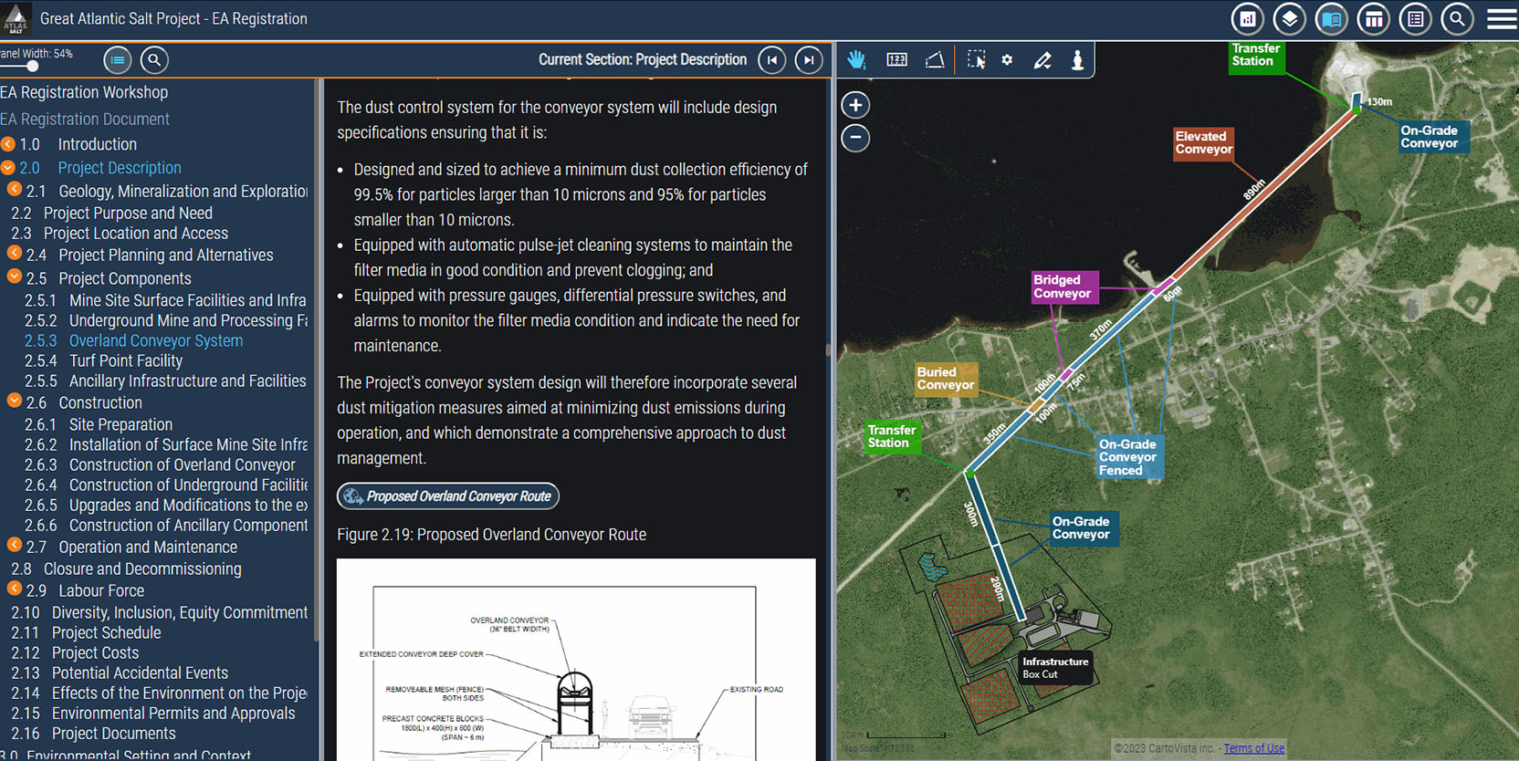
Mining

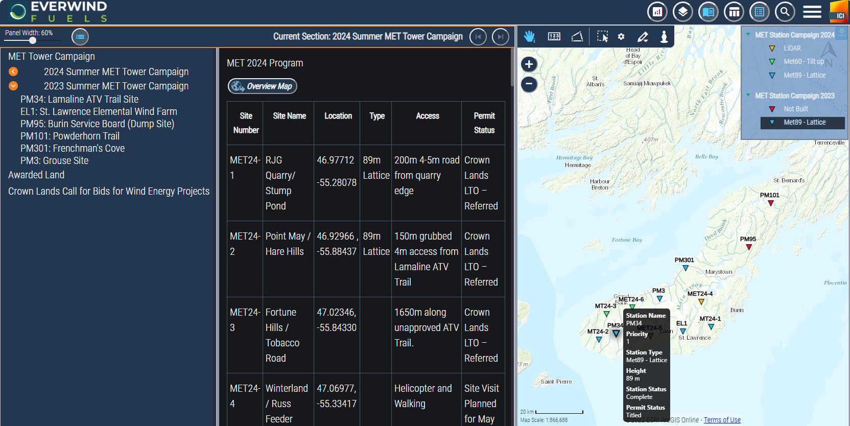
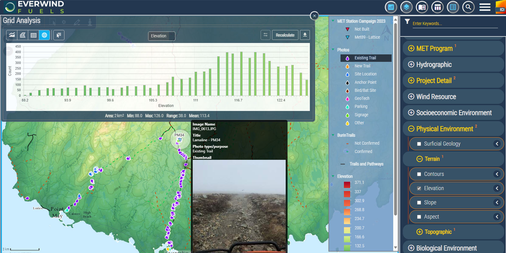
Renewable Energy

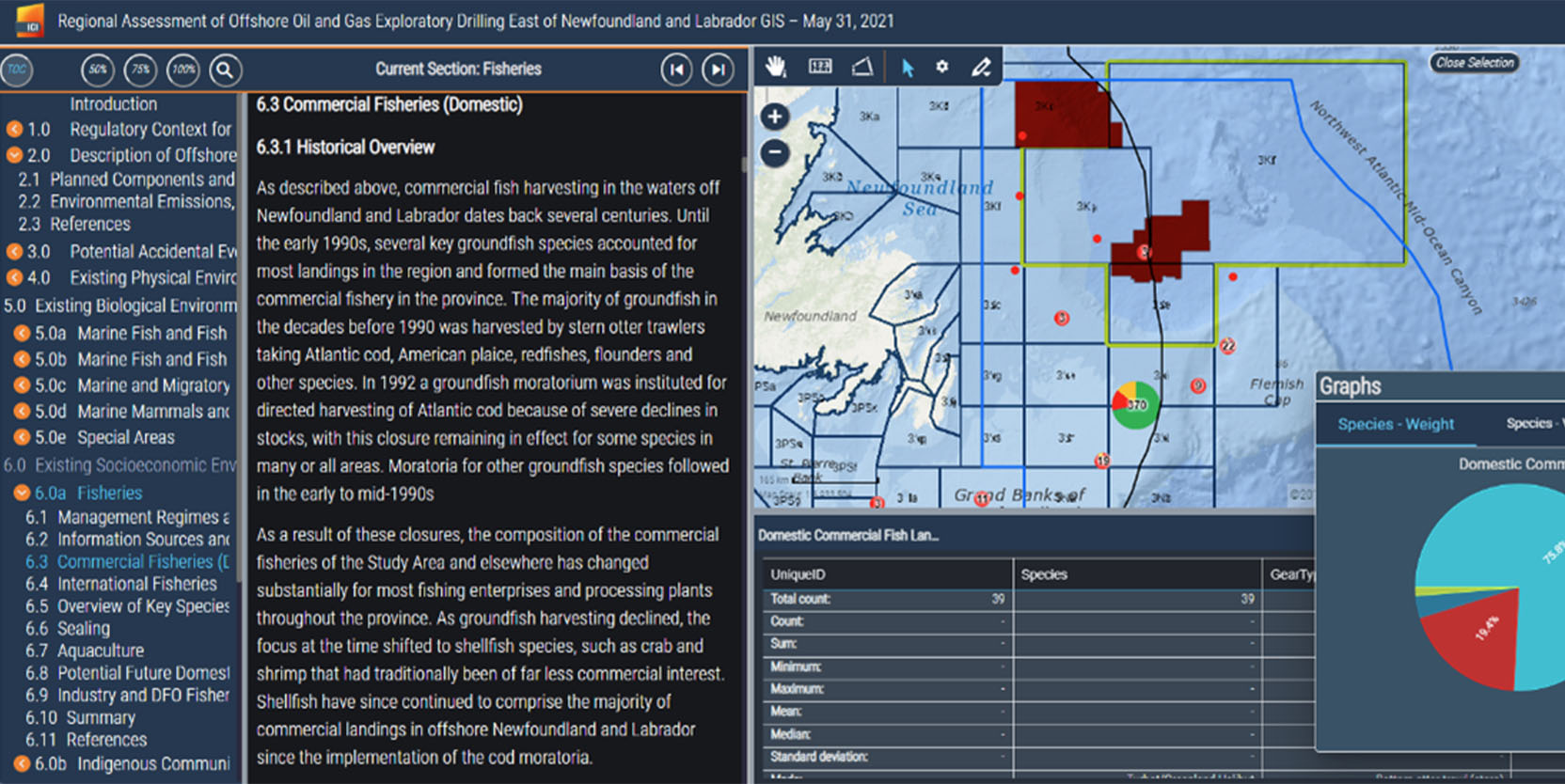
Oil & Gas

Transportation & Logistics

Fisheries

Interactive Data Visualization & Reporting
APPLICATIONS
Industries Served
Mining
Renewable Energy
Oil & Gas
Transportation & Logistics
Fisheries
Interactive Data Visualization & Report
TRUSTED BY
Our Clients

